Interactive Map
Explore thousands of postboxes with our interactive map. Filter by reign, search locations, and discover history.
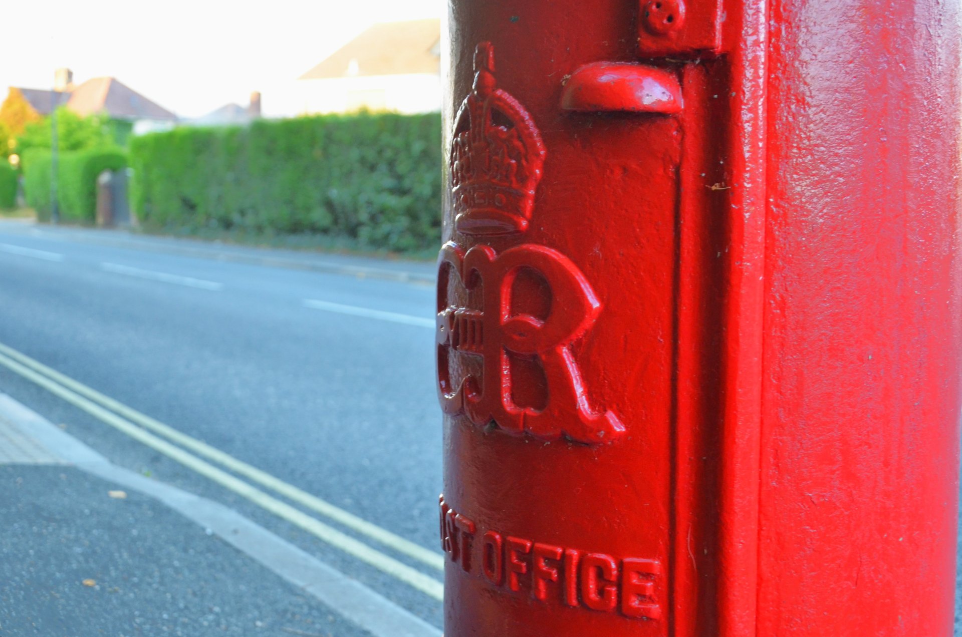
Photo: Steve Poole aka Stavioni · Flickr album
UK Postbox Map
Pin and log postboxes you've visited, add new finds to the map, and discover by location or reign. For spotters, enthusiasts, historians and contributors.
See how the community is growing, who's leading the board and what's catching people's eyes. Every approved postbox you add moves you up.
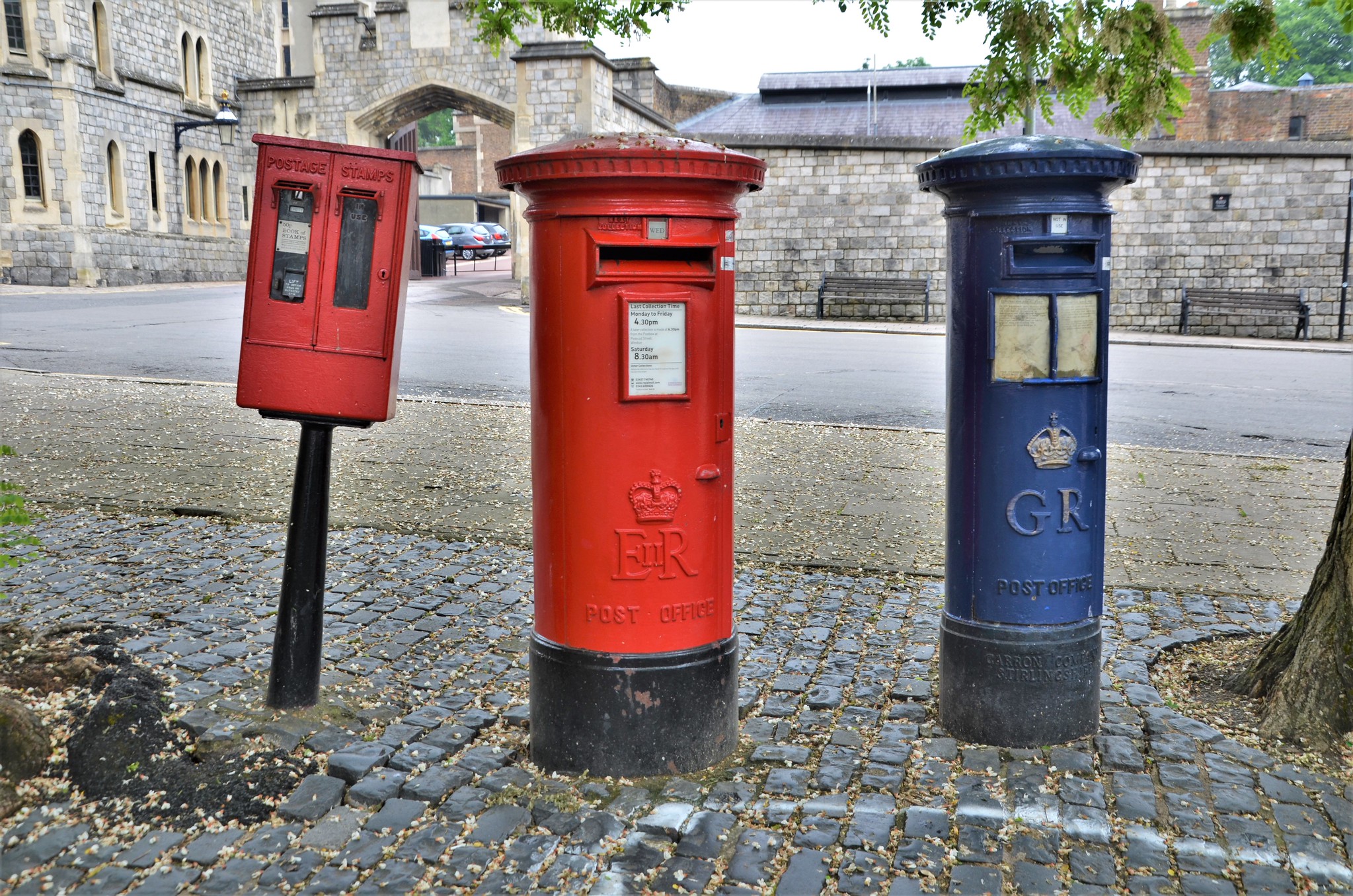
Postboxes (or pillar boxes, wall boxes, and lamp boxes) are a familiar part of the British landscape. They have carried the nation's mail since the 1850s, when the first standard roadside postboxes were introduced under Queen Victoria. Today, thousands of boxes remain in use across England, Scotland, Wales, and Northern Ireland, from Victorian and Edwardian boxes to the newest Charles III designs. A red pillar box on your high street might date from the reign of George V, Elizabeth II, or even Victoria, and still be in daily use.
Each postbox usually bears the royal cypher of the monarch in reign when it was made (e.g. VR, GR, E II R, C III R). That cypher is a small piece of history: it tells you when the box was installed and connects the street to a specific era. Enthusiasts and historians use these cyphers to identify and date postboxes, and to understand how the postal network has changed over time.
PostboxMap exists to document these boxes in one place. Whether you're a postbox spotter, enthusiast, local historian or contributor, you can pin and log ones you've visited and add new finds. We provide an interactive map where you can explore postboxes by location and reign, search by cypher or town, and contribute your own. Our identification guide explains how to recognise cyphers and types; our guide to UK postboxes gives more background on their history and why mapping them matters.
Explore thousands of postboxes with our interactive map. Filter by reign, search locations, and discover history.
Join a community of postbox spotters, enthusiasts, historians and contributors. Pin and log postboxes you've visited, contribute new ones, earn points, and help build the most comprehensive UK postbox database.
New to postbox spotting? Read our guide to UK postboxes and our identification guide for reigns and types.
From Victorian pillar boxes to modern designs. Find them on the map and add your own.
How to identify royal cyphers and typesPostboxMap is a map of UK postboxes built for people who enjoy discovering and documenting them. It helps postbox spotters, historians and enthusiasts record the location, type and royal cypher of pillar boxes, wall boxes and lamp boxes across the country.
There has never been a single public map showing where the UK's 115,000+ postboxes are. PostboxMap aims to change that: a structured, searchable dataset that anyone can explore and contribute to, with photos and records in one place.
Join thousands of contributors mapping postboxes across the UK. Free to join.
Get Started FreeFeatured quotes from people who use PostboxMap to explore, log visits, and add postboxes. More member quotes and longer stories live on our stories page.
“Why not be a part of recording over 150 years of postal history before post boxes become another “thing of the past”.”
“Finding and photographing postboxes to upload brings fun and curiosity to my outings.”
“Excellent and well thought out app. Easy to use and reliable. Adds an extra dimension of interest to walks and cycles!”
“I have been wanting someone to make this map forever! Postbox spotting can be a fun hobby but this makes it easier...”
“I like contributing to postbox map because I want to help build a comprehensive database of all publicly available...”
“Postbox Map has got me recording every box in my local area!”